青土湖间断性水淹干扰对白刺沙丘土壤特性的影响
作者: 宋龙龙 张芝萍
摘要 以青土湖过渡带3个不同立地类型(常淹水中的白刺沙丘、固定白刺沙丘、半固定白刺沙丘)的白刺灌丛沙丘为研究对象,采用空间代替时间的方法,测定间断性水淹前后白刺群落土壤水分、土壤理化性质等参数。结果表明,常淹水中的沙丘的土壤全氮含量总体在沙丘中部最大,沙丘上部次之,沙丘下部最小;固定沙丘的土壤全氮含量在沙丘上部较大,沙丘中部各土层的全氮含量均大于沙丘下部;半固定沙丘的土壤全氮含量在表土层达到最大值。常淹水中的沙丘的土壤全钾含量在沙丘上部表土层较低,沙丘中部表土层较高,沙丘下部在土层较深处全钾含量较高;固定沙丘的土壤全钾含量沙丘上部随着土层深度的增加,全钾含量变化不明显,沙丘中部在表土层最大;半固定沙丘的土壤全钾含量5~10 cm达到最大值,20~40 cm达到最小值。常淹水中的沙丘不同部位的土壤含水量均处于缓慢上升趋势;固定沙丘的土壤含水量在沙丘上部处于上升,沙丘中部先上升后下降,沙丘下部先下降后上升;半固定沙丘土壤含水量呈先上升后下降趋势。常淹水中的沙丘的土壤有机碳含量随着土壤深度的增加均呈不同程度降低趋势;在固定沙丘上,沙丘下部有机碳含量先上升后下降,沙丘中部有机碳含量先下降后上升,沙丘上部有机碳含量呈下降—上升—下降的趋势。在半固定沙丘上,有机碳含量随着土壤深度的增加而增加。
关键词 白刺;水淹;土壤含水量;土壤理化性质;青土湖
中图分类号 S719 文献标识码 A
文章编号 0517-6611(2023)06-0041-03
doi:10.3969/j.issn.0517-6611.2023.06.012
Effect of Intermittent Flooding Disturbance of Qingtu Lake on Soil Characteristics of Nitraria spinosa Sand Dune
SONG Long-long,ZHANG Zhi-ping
(Gansu Desert Control Research Institute,Lanzhou,Gansu 730070)
Abstract Three different site types of Nitraria spinosa shrub sandbags in the transition zone of Qingtu Lake (normally flooded, fixed and semi-fixed) were taken as the research objects, and the parameters of soil moisture and soil physical and chemical properties of Nitraria spinosa community before and after intermittent flooding were measured by using the method of space instead of time. The results showed that the total nitrogen content of the soil normally flooded was the largest in the middle of the sand dune, the second in the upper part of the sand dune, and the smallest in the lower part of the sand dune;the total nitrogen content of the soil in the fixed dune was larger in the upper part of the dune, and the total nitrogen content of each soil layer in the middle part of the dune was greater than that in the lower part of the dune;the soil total nitrogen content of semi-fixed dunes reached the maximum in the topsoil layer.The total potassium content of the topsoil layer normally flooded was lower in the upper topsoil layer of the sand dune, higher in the middle topsoil layer of the sand dune, and higher in the lower part of the sand dune;the total potassium content of fixed dunes in the upper part of the dune did not change significantly with the increase of soil depth, and the total potassium content in the middle part of the dune was the largest in the topsoil;the total potassium content of semi-fixed dune soil reached the maximum value at 5-10 cm and the minimum value at 20-40 cm.The soil water content in different parts of sand dunes in normal flooding was in a slow upward trend.The soil water content of fixed dunes was rising in the upper part of the dune, first rising and then falling in the middle part of the dune, and first falling and then rising in the lower part of the dune.The soil water content of semi-fixed dunes showed a trend of first increasing and then decreasing.The content of soil organic carbon in sand dunes in normal flooding decreased to varying degrees with the increase of soil depth.On fixed dunes, the organic carbon content in the lower part of the dune first rise and then decreased, the organic carbon content in the middle part of the dune first decreased and then rise,the organic carbon content in the upper part of the dune presented a downward-upward-downward trend.
Key words Nitraria spinosa;Flooding;Soil water content;Soil physical and chemical properties;Qingtu Lake
青土湖区域处于极度干旱地区,年降雨量在100 mm以下,生态系统恢复具有其特殊性。在极端干旱、贫瘠环境条件下生长发育的白刺灌丛沙堆,灌丛沙堆作为绿洲和沙漠之间一道重要的生态屏障,其最终的演化方向对绿洲地区的生态环境稳定有很大影响[1-6]。2010—2013年数次向石羊河尾闾青土湖注入生态用水,该区域大片白刺灌丛沙堆被水淹。因此,系统地调查研究青土湖区域间断性水淹前后不同演化阶段个体白刺沙堆的特征,明确白刺群落的土壤分布特征,探讨白刺沙堆在群落生态系统中结构和功能的基础性地位有其必要性和特殊意义,同时为其他地区白刺资源的保护和利用提供参考,也能为正确评估青土湖生态输水的生态效益及该地区植被保育和生态环境恢复提供科学依据[7-10]。
1 材料与方法
1.1 研究区概况
研究区域位于青海湖北岸,该地区南濒青海湖,北为大通山,地势由北向南倾斜,介于36°15′~38°20′N、97°50′~101°20′E,海拔3 200~3 800 m。该地区气候具有寒冷期长,太阳辐射强,气温日差较大,干旱少雨,降水比较集中,雨热同季,且无明显四季之分,属高原大陆性气候。据刚察县气象观测资料分析,年平均气温为-0.6 ℃,极端最高温25.0 ℃,极端最低温-31.0 ℃,≥0 ℃的年活动积温为1 299 ℃·d,年降水量370.3 mm,年蒸发量607.4 mm,干旱指数为4.34,平均风力大于8级,最大冻土深度2.88 m,土壤为栗钙土。
1.2 研究方法
1.2.1 样地设置。
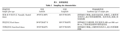
以空间代替时间序列的方法,按照白刺灌丛沙丘形态、植被生长状况、沙丘土壤状况,分别选择3种不同立地类型(常淹水中的白刺沙丘、固定白刺沙丘、半固定白刺沙丘)的白刺沙丘群落(表1),每个立地类型选6个样地,在每个样地中设置30 m×30 m灌木样方,并在每个灌木样方内的中心和4个角处共设置5个1 m×1 m的草本植物调查样方,逐株调查样方内所有植物种的种类、株树(丛数)、盖度以及生物量。并在不同立地类型的白刺沙丘取土样0~60 cm(0~5、5~10、10~20、20~40、40~60 cm),测其土壤理化性状、土壤含水率等土壤性质。使用全球定位系统(GPS)对调查地点定位,并记录各样地的海拔、地貌及土壤类型等环境因子[11-16]。
1.2.2 测定方法。
土壤含水量采用烘干法,pH采用电位计法(水土比为5∶1),有机质采用重铬酸钾-外加热法,有效氮采用碱解扩散法,有效磷采用碳酸氢钠浸提-钼锑抗比色法,有效钾采用乙酸铵浸提-火焰光度法;利用马尔文激光粒度仪进行土壤粒度的测定[17-22]。粒度分析的粒级是0.02~2 000.00 μm。土壤水分测定采用烘干法,容重采用环刀法。
1.3 数据处理与分析 对所得试验数据用 Excel 2013记录,求取平均值,进行数据分类和绘图,并利用 SPSS 18.0 统计分析软件进行观测数据的显著性检验和相关分析。
2 结果与分析
2.1 不同立地类型的白刺样地土壤全氮和全钾含量 从图1可以看出,常淹水中的沙丘的土壤全氮含量在沙丘中部0~40 cm大于沙丘下部和上部,并且随着土层的增加,全氮含量减少,而沙丘下部全氮含量呈“U”型;沙丘上部的全氮含量和沙丘中部在0~40 cm有相似的变化趋势,但是40~60 cm正好相反;总体来看,全氮含量在沙丘中部最大,沙丘上部次之,沙丘下部最小。固定沙丘的土壤全氮含量在沙丘上部较大,在20~40 cm达到最大,在40~60 cm最小;沙丘中部各土层的全氮含量均高于沙丘下部。半固定沙丘的土壤全氮含量,0~5 cm达到最大值,5~10 cm达到最小值。
从图2可以看出,常淹水中的沙丘的土壤全钾含量在沙丘下部20~40 cm最大,10~20 cm最小;沙丘中部全钾含量0~5 cm最大,40~60 cm最小;沙丘上部全钾含量0~5 cm最小,10~20 cm最大。固定沙丘的土壤全钾含量在沙丘上部随着土层深度的增加变化不显著;沙丘中部全钾含量0~5 cm最大,40~60 cm最小;沙丘下部全钾含量20~40 cm最大,5~10 cm 最小。半固定沙丘的土壤全钾含量,5~10 cm达到最大值,20~40 cm达到最小值。
2.2 不同立地类型的白刺样地土壤含水量 从图3可以看出,常淹水中的沙丘的土壤含水量沙丘上部和下部的变化不是很大,沙丘上部一直处于上升趋势,而沙丘下部在40~60 cm开始下降,但是沙丘中部一直处于缓慢上升趋势,在40~60 cm上升趋势比较明显且达到了最大值;由此可见,沙丘上部和下部土壤含水量的变化不大,而沙丘中部土壤含水量的变化较为明显。在固定沙丘上,沙丘下部土壤含水量先下降后上升;沙丘中部土壤含水量0~40 cm是上升,而在40~60 cm处于下降趋势;沙丘上部土壤含水量一直处于上升趋势;而且在40~60 cm沙丘不同部位的值相近。在半固定沙丘上,土壤含水量在10~20 cm达到了最大值,20~60 cm处于下降趋势,而在0~5 cm为最小值。
2.3 不同立地类型的白刺样地土壤有机碳含量
从图4可以看出,常淹水中的沙丘有机碳在沙丘下部5~10 cm达到最大值,之后随着土壤深度的增加有机碳含量一直在减少;沙丘中部和上部有机碳含量均在10~20 cm为最大,之后随着土壤深度的增加有机碳含量呈减小趋势。在固定沙丘上,沙丘下部有机碳含量先上升后下降,最小值在40~60 cm,最大值在5~10 cm;沙丘中部有机碳含量先下降后上升,最小值在10~20 cm,最大值在40~60 cm;沙丘上部有机碳含量呈下降—上升—下降的趋势,最小值在40~60 cm,最大值在0~5 cm。在半固定沙丘上,有机碳含量随着土壤深度的增加而增加;在0~5 cm土层有机碳含量较小,而随着土层的加深,有机碳含量是逐层增加,在40~60 cm达到最大。