嫩江流域多年降水特征分析
作者: 鹿之慧 王东升 王丹宁 潘帅
摘要 [目的]探究嫩江流域降水及季节性降水变化特征。[方法]选取该流域内10个气象站,基于1969—2010年逐日降水数据,计算年降水量及冬夏季降水量,采用Mann-Kendall趋势检验法分析流域降水变化趋势,采用Theil-Sen estimator来计算趋势幅度,并利用Mann-Kendall突变检测法确定流域降水量发生突变的关键节点,综合分析嫩江流域降水的时间变化特征。[结果]近42年来嫩江流域年降水量以4.7 mm/10 a的幅度不显著下降,夏季降水量下降幅度(10.1 mm/10 a)高于年降水量,冬季降水量则表现为显著上升趋势,变化幅度为1.3 mm/10 a。嫩江流域年降水量为373.1~507.8 mm,夏季降水量为231.7~309.4 mm,冬季降水量为3.6~11.4 mm,中上游的降水量高于下游,10个站点年降水量主要以下降趋势为主,夏季降水量均表现为下降趋势,除乾安站降水量不显著下降外,其他站点冬季降水量均表现为上升趋势。夏季降水变化与年降水表现为较高的相似性,两者的Mann-Kendall突变检验结果也在形态上非常相近,均出现3个阶段的趋势变化,且波峰相近;在20世纪70年代前后为第1阶段,表现为减少趋势;80—90年代为第2阶段,表现为增加趋势;21世纪初期为第3阶段,再次表现为下降趋势。在0.05显著性水平上,年、夏季降水量在20世纪70年代前后和21世纪初期存在多个突变点,降水减少阶段变化较不稳定,增加阶段无交点存在。冬季与年、夏季结果差异较大,表现为在1973—1978和1980—1986年降水量下降,其他时间段降水量上升;1998年为0.05显著性水平上的交点。[结论]嫩江流域多年降水特征以夏季降水量占年降水量比重大,且经历了减少—增加—减少趋势变化,最终表现为减少趋势。冬季降水量在1998年出现突变节点,该年之后冬季降水量显著增加。夏季降水是洪涝隐患之一,但多年来,不断增长的冬季降水变化也要给予关注。
关键词 降水量;变化特征;Mann-Kendall检验;趋势分析;突变检验;嫩江流域
中图分类号 S 162 文献标识码 A 文章编号 0517-6611(2023)01-0204-04
doi:10.3969/j.issn.0517-6611.2023.01.046
Analysis on Characteristics of Annual Precipitation in Nenjiang River Basin
LU Zhi-hui,WANG Dong-sheng,WANG Dan-ning et al
(College of Environmental Science and Engineering,Liaoning Technical University,Fuxin,Liaoning 123000)
Abstract [Objective]To investigate the characteristics of precipitation and seasonal precipitation changes in the Nenjiang River Basin.[Method]Ten meteorological stations in the area were selected to calculate the annual precipitation and the winter and summer precipitation based on their daily precipitation data from 1969 to 2010. The trend of precipitation change and its range were analyzed and calculated by using the Mann-Kendall Test and the Theil-Sen estimator respectively, and the Mann-Kendall method in detecting climate mutation was adopted to determine the key nodes where sudden changes in rainfall occur in the basin, and comprehensively analyze the temporal variation characteristics of precipitation in Nenjiang River Basin.[Result]Over the past 42 years, the annual precipitation in the Nenjiang River Basin had decreased insignificantly by 4.7 mm/10 a. The summer precipitation had decreased more than the annual precipitation by 10.1 mm/10 a,while the winter precipitation had shown a significant upward trend than the annual precipitation by 1.3 mm/10 a.The annual precipitation in the region was 373.1-507.8 mm, with the summer and winter precipitation was 231.7-309.4 mm and 3.6-11.4 mm. Precipitation in the middle and upper reaches was higher than in the lower reaches. The annual precipitation at 10 stations was commonly decreasing, especially in summer. Except Qian’an station, where the precipitation does not decrease significantly, all other stations show an increasing trend of winter precipitation. The changes of summer precipitation and annual precipitation showed a high similarity.The results of the Mann-Kendall mutation test for both were also very similar in morphology, with both showing a 3-phase trend change and similar wave crests. It could be summarized as the first stage around the 1970s, which showed a decreasing trend;the second stage in the 1980s-1990s, showing an increasing trend;and the third stage in the early 21st century, which again showed a decreasing trend. At the 0.05 significance level, there were several abrupt change points in the annual and summer precipitation around the 1970s and the early 21st century, and the change in the decreasing phase of precipitation was more unstable, and no intersection point existed in the increasing phase. The difference between winter and annual and summer results was larger, featuring a decrease in precipitation around 1973-1978 and 1980-1986, and an increase in precipitation in other periods;1998 was the intersection point at 0.05 significance level. [Conclusion]The multi-year precipitation characteristics of the Nenjiang River Basin were featured with a large proportion of annual precipitation in summer, and it had experienced a decreasing-increasing-decreasing trend change, and finally showed a decreasing trend. The winter precipitation showed a sudden change node in 1998, and the winter precipitation increased significantly after that year. Summer precipitation was one of the flooding hazards, but the increasing winter precipitation changed over the years should also be given attention to.
Key words Precipitation;Change characteristics;Mann-Kendall test;Trend analysis;Mutation test;Nenjiang River Basin
作者简介 鹿之慧(1996—),女,辽宁阜新人,硕士研究生,研究方向:生态修复理论。
通信作者,教授,博士,硕士生导师,从事矿山环境修复研究。
收稿日期 2022-02-23
降水趋势变化因其对区域生态系统状况、河流、湖泊等水文过程影响深刻被广泛关注[1-2],位于东北的嫩江流域作为重要的粮食和湿地分布区,因其地理位置特点,对全球变化的敏感性较高[3-4]。夏季洪涝灾害对农业生产造成的影响较大。1970—1990年洪涝发生频率达47.6%[5],给人们生产生活造成一定损失。降水作为重要的水文要素[6]和灾害性天气的重要诱因[7]之一,研究嫩江流域多年降水变化特征,可为流域农业发展、水资源环境及环境保护提供决策依据[8]。目前,不少学者对东北地区降水变化进行了研究并取得了一定成果[9-12]。笔者以嫩江流域为研究对象,选用流域1969—2010年逐日降水数据,以Mann-Kendall趋势分析、Mann-Kendall突变检验法为技术支撑,分析流域多年降水及冬、夏两季降水特征,为流域农业生产和生态环境管理与决策提供参考[6]。
1 资料与方法
1.1 研究区概况
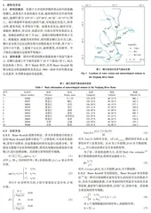
发源于大兴安岭伊勒呼里山的中段南侧的嫩江,是黑龙江水系的最长支流,地处我国东北中高纬度地区,地理位置为119°15′~127°40′E、44°26′~51°37′N(图1)。属于寒温带半湿润大陆性气候,年际温差变化大,四季分明,夏季多雨,冬季寒冷干燥。流域水系发达,拥有甘河、诺敏河、雅鲁河、淖尔河、讷谟尔河、乌裕尔河等多条较长支流。流域总面积达29.7万km2。流域以暗棕壤和草甸土为主。依据地形、地貌及河谷特征,将河源至嫩江县分为上游,嫩江县至莫力达瓦达斡尔族自治旗驻地分为中游,其下至三岔河口为下游。上游属于山丘区,森林繁茂,河谷狭窄。中下游由丘陵逐步过渡到平原地区。
1.2 资料来源
研究中使用的降水数据来源于国家气象中心,在嫩江流域上中下游共选取了10个气象站(图1),站点信息如表1所示。基于Matlab软件,采用Mann-Kendall趋势分析法分析流域整体及各站点1969—2010年的年降水量以及夏季、冬季降水量的变化趋势。
2 结果与分析
2.1 流域年、冬夏季降水量时间趋势变化分析
从1969—2010年嫩江流域年降水量变化(图2)可以看出,近42年来嫩江流域年降水量最低值发生于2001年,受1998年洪水影响,降水量在1998年达到峰值,降水量年际变化波动较大。流域年降水量以4.7 mm/10 a的幅度不显著下降。
从1969—2010年嫩江流域冬夏季降水量变化(图3)可以看出,近42年来嫩江流域夏季降水量接近年降水量,同样在1998年达到峰值。流域夏季降水量无显著下降,下降幅度高于年降水量,为10.1 mm/10 a。冬季降水量则表现为显著上升趋势,上升幅度为1.3 mm/10 a,冬季降水量的峰值在2010年。夏季降水量与年降水量变化表现出较高的相似性。
2.2 各站点年、冬夏季降水量时间趋势变化分析
近42年来流域10个站点年降水量变化结果(表2)显示,嫩江流域年降水量为373.1~507.8 mm,中上游的年降水量高于嫩江下游,其中,位于中游的北安站年降水量最大,位于下游的白城站年降水量最小。Mann-Kendall检验结果表明,嫩江流域多年降水量变化幅度在2.7~26.4 mm/10 a,其中,诺敏河附近的小二沟站多年降水量以2.7 mm/10 a的变化幅度上升、乌裕尔河附近的北安站以6.2 mm/10 a的幅度上升、雅鲁河附近的龙江站以10.4 mm/10 a的幅度上升、洮儿河附近的索伦站以9.8 mm/10 a的幅度上升;其他站多年降水量均呈下降趋势,且主要集中在流域下游。除齐齐哈尔站和乾安站多年降水量显著下降,其他站点降水量均呈现不显著变化。
近42年来流域10个站点夏季降水量变化结果(表3)显示,嫩江流域夏季降水量为231.7~309.4 mm,中上游的降水量高于嫩江下游,其中,位于诺敏河附近的小二沟站和乌裕尔河附近的北安站夏季降水量较大,分别为309.4和306.7 mm,位于的泰来站和白城站夏季降水量最小,均为231.7 mm。Mann-Kendall检验结果表明,嫩江流域10个站点夏季降水量变化幅度在1.6~28.8 mm/10 a,均表现为下降趋势,且索伦站下降幅度最小,齐齐哈尔站最大。其中,齐齐哈尔站和乾安站显著下降,其他站点均不显著下降。
近42年来流域10个站点冬季降水量变化结果(表4)显示,嫩江流域冬季降水量为3.6~11.4 mm,中上游的冬季降水量高于下游,其中,小二沟站、嫩江站和北安站冬季降水量相近,分别为10.3、11.2和11.4 mm。Mann-Kendall检验结果表明,嫩江流域冬季降水量变化幅度在0.1~2.3 mm/10 a,除乾安站降水量不显著下降外,其他站均表现为上升趋势。与夏季降水量相反,齐齐哈尔站和白城站上升趋势并不显著,其他站点则显著上升。
2.3 流域突变检测分析
对流域年降水量、夏季降水量进行Mann-Kendall突变检验,结果如图4a~b所示,年降水量突变检验结果与夏季降水量十分相似。年降水量出现共3个阶段的趋势变化,1969—1981年表现出减少趋势,为第1阶段;1982—1999年表现为增加趋势,为第2阶段;2000—2010年表现为减少趋势,为第3阶段。夏季降水量变化也包含3个阶段,1969—1983年表现为减少趋势,1984—2001年表现为上升趋势,2002—2010年表现为减少趋势。年、夏季降水量整体表现为20世纪70年代前后减少,80—90年代增加,在21世纪初期减少。在α=0.05显著性水平上,UF统计量与UB统计量相交于2个降水量减少阶段,且存在多个突变点,变化较不稳定。年、夏季降水量增加阶段无交点存在,即1981—1999年年降水量和夏季降水量均表现为稳定上升趋势,无突变上升情况产生。