1967—2017年新疆降水分配时空特征研究
作者: 柳宏斌 连帅明 白悦莹 景云云 许仲林
摘要 利用新疆全域50个站台1967—2017年逐日降水资料,通过对降水集中度与集中期的计算,分析新疆降水年内分配的不均匀性。结果表明,研究时段内北疆多年平均降水日数大于50 d,西部、北部山区可达90 d,南疆仅西部、北部沿天山地区达30~50 d,南疆其余区域及东疆均小于20 d;新疆降水量呈现增加趋势,降水日数及降水强度均有所增加;降水变异系数与多年平均降水量呈负相关,即降水越多的区域,年际差异越小,全疆降水变异系数在0.20~0.65,呈由北向南递增态势;全疆降水集中度在0.17~0.78,自北向南增大,降水分配趋于集中,且研究时段内降水集中度以0.011/10 a速度降低;全疆降水集中期在6月中旬至8月初,自西南向东北推迟,南疆最先进入集中降水期;在典型年中,南北疆的变化以降水强度为主,东疆以降水日数变化为主;新疆降水存在显著周期,现在阶段处于25~32年的降水偏少周期,且处于降水集中度由低向高转变的交替过程中。
关键词 降水量;降水强度;降水集中度;降水集中期;时空特征
中图分类号 S 161.6 文献标识码 A 文章编号 0517-6611(2023)03-0213-08
doi:10.3969/j.issn.0517-6611.2023.03.049
Study on Temporal and Spatial Characteristics of Precipitation Distribution in Xinjiang from 1967 to 2017
LIU Hong-bin1,2,LIAN Shuai-ming1,2,BAI Yue-ying1,2 et al
(1.College of Geographical Science,Xinjiang University,Urumqi,Xinjiang 830046;2.Xinjiang Key Laboratory of Oasis Ecology,Xinjiang University,Urumqi,Xinjiang 830046)
Abstract Based on the daily precipitation data of 50 stations in Xinjiang from 1967 to 2017,the heterogeneity of precipitation distribution in Xinjiang was analyzed by calculating the precipitation-concentration degree(PCD) and precipitation-concentration period(PCP).The results showed that the multi-year average number of precipitation days during the study period was greater than 50 days in northern Xinjiang and up to 90 days in the western and northern mountainous areas of northern Xinjiang.Only the western and northern areas along the Tianshan Mountains in southern Xinjiang reach 30-50 days,while the rest of southern Xinjiang and eastern Xinjiang were less than 20 days.Precipitation in Xinjiang showed an increasing trend,with an increase in the number of precipitation days and average precipitation intensity.The variation coefficient of precipitation was negatively correlated with the multi-year average precipitation,which meant that regions with more precipitation had less inter-annual variation.The variation coefficient of precipitation in Xinjiang was 0.20-0.65,with an increasing trend from north to south.The precipitation-concentration degree in Xinjiang was 0.17-0.78,increasing from north to south,and the precipitation distribution tended to be centralized.During the study period,the precipitation-concentration degree decreased at a rate of 0.011/10 a.The precipitation-concentration period in Xinjiang was from mid-June to early August,delayed from southwest to northeast,with southern Xinjiang being the first to enter the period of concentrated precipitation.In a typical year,the changes in southern and northern Xinjiang were dominated by changes in precipitation intensity and in eastern Xinjiang by changes in precipitation days.There were significant cycles of precipitation in Xinjiang,and the present stage was in a 25-32 a cycle of low precipitation and in the process of alternating from low to high precipitation concentrations.
Key words Precipitation;Precipitation intensity;Precipitation-concentration degree(PCD);Precipitation-concentration period(PCP);Temporal and spatial characteristics
基金项目 新疆维吾尔自治区高校科研计划项目(XJEDU2020Y008) 。
作者简介 柳宏斌(1997—),男,新疆石河子人,硕士研究生,研究方向:自然地理。通信作者,教授,博士,硕士生导师,从事GIS与数学建模方面的工作。
收稿日期 2022-03-25
降水的分配对于水资源利用、作物生长及生产生活具有重要意义。针对降水的时空分布问题,国内外已有许多学者进行了研究。国外研究多采用降水集中指数(precipitation concentration index,PCI)[1-3]、基尼系数(Gini index,GI)[4-5]等方法进行集中降水分布的研究。如Cortesi等[6]采用日降水集中指数对欧洲1971—2010年530个日降水序列进行分析,结果发现,年度及季节性日降水最大值出现在地中海西部沿西班牙及法国海岸线,纬度及离海距离似乎对降水集中指数的空间分布起着主要作用。Monjo等[7]采用了基尼系数(GI)、降水集中指数(PCI)、泰尔指数(Theil index)等方法对一组世界降水序列进行降水集中度评估,并对各指数的结果进行对比,发现几个指数间有很强的联系,并呈现出相同的高、低集中降水相对区域。国内学者如杨若子等[8]对华北地区降水气候特征进行了分析,发现研究时段中研究区因夏季降水的减少而导致年降水量减少,且降水强度呈增大趋势,降水时间更加集中;商沙沙等[9]利用西北地区气象台站的逐月气温和降水资料,对西北地区气温及降水的时空变化特征进行了研究,发现西北地区的气温及降水呈现波动上升趋势,年平均气温增加集中于准格尔盆地及天山西南部,降水增加在河西走廊东部地区较为显著。
新疆深居欧亚大陆腹地,远离海洋,气候干燥,是气候变化的敏感区。全年降水少且多集中于夏季,强降水多发生于6—8月。对新疆降水的研究集中于降水的时空分布特征[10-13]以及降水的水汽来源[14-19]、输送过程[20]、动力机理和环流背景[21-23]等方面。如张强等[24]采用Copula非参数估计方法分析了新疆极端降水概率的时空分布特征,发现北疆较南疆湿润,且发生极端降水的概率较大,在同年中发生长历时降水的概率山区较平原大,发生强度较大的降水事件概率天山南坡大于其他地区;刘海军等[25]结合新疆65个气象站点日降水数据,采用连续、分类验证统计方法对RFE2.0遥感数据在新疆的适用性进行了评价,并实例验证了RFE2.0在新疆的可靠性。相关研究加深了对于新疆降水时空特征的理解,但对新疆降水年内分配的研究鲜见报道。该研究对新疆50个站点1967—2017年降水年内分配格局、降水集中度、集中期的变化规律,以及降水日数、降水强度等相关指标进行分析,以期为探讨区域降水分配特征提供参考。
1 资料与方法
1.1 研究区概况
新疆维吾尔自治区(73°40′~96°18′E、34°25′~48°10′N)位于我国西北边疆,面积166万km2,全区边境多山,山脉与盆地相间排列。北部为阿尔泰山,南部为昆仑山,天山山脉横贯其中,将新疆分为南北两部,因此地形整体呈现“三山夹两盆”分布。本区远离海洋,深居内陆,大陆性气候明显,气温变化剧烈,日照充足,降水稀少,各地降水量差异大。
1.2 数据来源 该研究所使用的降水资料为1967—2017年逐日降水(以24 h降水计)观测资料,来源于中国气象数据网(http://data.cma.cn),进行数据质量分析,并对缺失值进行插补,剔除连续缺失数据的站点,最终保留50个站点(图1)。
1.3 研究方法
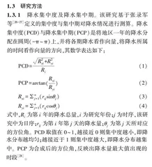
1.3.1 降水集中度及降水集中期。该研究基于张录军等[26-27]定义的集中度与集中期对降水情况进行测算。降水集中度(PCD)与降水集中期(PCP)是将地区一年的降水分配在圆周(-π~π)上,并将各期降水看作向量,将降水所属的时间看作向量的方向,其数学表达如下:
PCD=R2xi+R2yiRi(1)
PCP=arctan(RxiRyi)(2)
Rxi=nj=1(rijsinθj)(3)
Ryi=nj=1(rijcosθj)(4)
式中,Ri为第i 年的降水总量,i为研究年份;j为时序,该研究中为日序;rij为第i年第j天的降水量;θj为第j天所对应的方位角。PCD取值在0~1,越接近0则集中度越小,即降水分布越均匀;越接近于1则集中度越大,即降水分布越集中。PCP为合成后的方位角,反映出降水量最大值出现的时段[28]。
1.3.2 插值及面状降水量评估方法。
克里金插值法相较于其他插值方法具有更多优势,不仅提高了插值精度,也在一定程度上降低了由于采样不均匀所产生的误差[29-30]。因此,该研究选择克里金法对降水量、降水集中度(PCD)、降水集中期(PCP)、变异系数等进行空间插值。
为了避免数据叠加造成面状区域降水估算过程中数据空间特征缺失,采用泰森多边形法对区域降水量进行估算[31]。泰森多边形能保证在每个多边形内重心附近有一个站点,通过多边形面积对站点赋权,计算所形成面域的总体降水量。同时,依据行政区划采用泰森多边形法划定该研究的东疆、南疆、北疆分区(图2),并对分区降水进行估算。
此外,该研究采用变异系数对研究区降水变异性进行测度,采用相关系数及线性趋势法对研究区年内降水分配进行测度。