基于“PLUS-FAHP-FCE”模型的耕地布局评价方法研究
作者: 王向明 郭敏 李明惠 熊侣英 朱君玉 陈颖芝
摘要 [目的]丰富和完善耕地布局评价方面的研究成果。[方法]基于对实现耕地总量动态平衡、提升耕地连片度、提升耕地地力、促进可持续利用、增强耕地生态系统的抗逆性和缓冲性的需求,提出首先构建基于“目标-需求-维度-指标”耕地布局评价指标体系框架,以广东省河源市为例,通过PLUS模型法模拟河源市惯性发展、耕地保护、生态优先3种土地利用模拟情景,围绕数量、布局、质量、生态4个维度,共选取11个单项指标,构建河源市耕地布局评价指标体系,运用FAHP分析法确定各评价指标的权重,根据确定的耕地布局评价指标体系进行FCE评价,得出耕地布局效果得分。[结果]河源市在耕地保护模拟情景的FCE得分最高,表现为区域耕地空间布局进一步集聚,大部分坡度15°以下林地演变为耕地,多数坡度25°以上耕地演变为林地,且生物多样性、碳储量总体呈现下降趋势;生态保护情景的FCE得分次之,耕地空间集聚程度较耕地保护情景低,生物多样性、碳储量总体上升趋势;在河源市耕地布局指标中,数量维度与生态维度呈现负相关;耕地保护情景有效约束了建设用地扩张,生态优先情景中林地、水域(包括未利用地)等生态用地显著增加。[结论]基于“PLUS-FAHP-FCE”的耕地布局评价方法具有可行性。
关键词 耕地布局评价;PLUS-FAHP-FCE;土地利用;河源市
中图分类号 S 28 文献标识码 A 文章编号 0517-6611(2025)01-0250-07
doi:10.3969/j.issn.0517-6611.2025.01.052
开放科学(资源服务)标识码(OSID):
Research on Cultivated Land Layout Evaluation Method Based on “PLUS-FAHP-FCE” Model—Taking Heyuan City,Guangdong Province as an Example
WANG Xiang-ming GUO Min LI Ming-hui3 et al
(1.Guangdong Jingdi Planning Technology Co.,Ltd.,Guangzhou,Guangdong 510000;2.Zhongkai University of Agriculture and Engineering,Guangzhou,Guangdong 510000;3.Guangdong Provincial Land Development and Consolidation Center,Guangzhou,Guangdong 510000)
Abstract [Objective]In order to enrich and improve the evaluation index system for optimizing farmland layout.[Method]Based on the needs of realizing the dynamic balance of total cultivated land,improving the contiguity of cultivated land,improving the soil fertility of cultivated land,promoting sustainable use,and enhancing the stress resistance and buffering of cultivated land ecosystem,this paper proposes to construct a framework for the construction of cultivated land layout evaluation index system based on “goal-demand-dimension-index”,taking Heyuan City as an example,and simulating three land use simulation scenarios of Heyuan City,including inertial development,cultivated land protection and ecological priority,through the PLUS model method.Focusing on the four dimensions of quantity,layout,quality and ecology,a total of 11 individual indicators were selected to construct the cultivated land layout evaluation index system in Heyuan City,and the FAHP analysis method was used to determine the weight of each evaluation index,and the FCE evaluation was carried out according to the determined cultivated land layout evaluation index system,and the cultivated land layout effect score was obtained.[Result]Heyuan City has the highest FCE score in the cultivated land protection simulation scenario,which shows that the spatial distribution of cultivated land in the region is further agglomeration,most of the forest land with a slope of less than 15° has evolved into cultivated land,and most of the cultivated land above 25° has evolved into forest land,and the biodiversity and carbon storage have generally shown a downward trend.The FCE score of the ecological protection scenario was the second,and the spatial agglomeration degree of cultivated land was lower than that of the cultivated land protection scenario,and the overall upward trend of biodiversity and carbon storage was high.In the cultivated land layout index of Heyuan City,the quantity dimension is negatively correlated with the ecological dimension.The cultivated land protection scenario effectively constrains the expansion of construction land,and the ecological land such as forest land and water area (including unused land) increases significantly in the ecological priority scenario.[Conclusion]The cultivated land layout evaluation method based on “PLUS-FAHP-FCE” is feasible.
Abstract Cultivated land layout evaluation;PLUS-FAHP-FCE;Land use;Heyuan City
基金项目 广东省耕地保护政策研究项目(GDTDZZ-2023020-010203);广东省自然资源厅科技项目(GDZRZYKJ2024009);广东省自然资源厅科技项目(GDGTKJ2018003)。
作者简介 王向明(1988年—),男,河北衡水人,工程师,从事城乡规划与耕地保护研究。*通信作者,工程师,硕士,从事国土空间生态修复与耕地保护。
耕地布局优化是提升耕地生产力的重要基础和前提,有利于土地利用合理管理、耕地系统安全的提升,能够维持区域耕地系统安全和实现土地可持续利用[1-2],最终使得农业生产空间更符合自然地理格局、实现耕地集中连片、提升耕地质量、改善耕地耕作层,进而巩固我国粮食安全根基。优化耕地布局,必须秉持“山-水-林-田-湖-草-沙”一体化保护理念,按照自然生态的整体性、系统性及其内在规律,结合适宜性原则开展系统治理,使各类要素各得其所,相得益彰。稳妥推进“山上”换“山下”,将山上耕地逐步调整到山下,推动果树苗木尽量上山上坡,是持续优化耕地布局的重点任务之一[3]。贺勇[4]总结了浙江省优化耕地布局工作中的典型做法,分析了耕地空间治理中存在的突出困难及风险,并提出了相关建议。目前有关耕地空间方面的研究成果,集中于永久基本农田空间布局的优化方式及实践研究。较多学者针对耕地中比较重要的永久基本农田空间布局优化开展了相关研究,陈文广等[5-7]对省域、县域等不同空间尺度下的永久基本农田布局优化规则开展了研究及实践,李凯等[8]以GIS网格技术为切入点,科学划定宜兴市永久基本农田。这些研究成果为耕地空间布局的优化、科学评价提供了理论基础。与此同时,较多研究成果围绕耕地特别是永久基本农田的质量综合评价指标构建[9-10]、永久基本农田划定规则[7-11]等方面展开,多以耕地质量评价为切入点,主要从耕地地力[12]、设施完备度[13]、区位条件[14]、政策条件[15]等多方面对耕地进行评价。现有研究中,在耕地综合评价指标方面多为考虑粮食安全、耕地质量等因素[16-18],鲜少考虑生态保护的评价指标,同时尚未有研究建立相关评价指标体系,来评价某地土地利用变化后耕地空间布局优化的结果。作为中国经济发展最快的地区之一,广东省土地资源十分紧缺,耕地破碎化程度较高;面对不断增长的发展诉求和耕地后备资源不足的困境,急需优化耕地布局,提高耕地利用效率。
综上,笔者基于“目标-需求-维度-指标”的耕地布局评价指标体系框架,提出耦合“PLUS-FAHP-FCE”模型的耕地布局评价方法,并以广东省河源市为例,模拟其3种设定情景下的土地利用变化后,围绕需求建立相应的耕地布局指标评价体系,评价耕地布局效果,形成一套数据易获取、方法简便可行的耕地布局评价方法,以期为新形势下广东省优化区域耕地布局、统筹划定耕地集中整治区后期的评价验收及各级国土空间规划的科学评估提供思路借鉴。
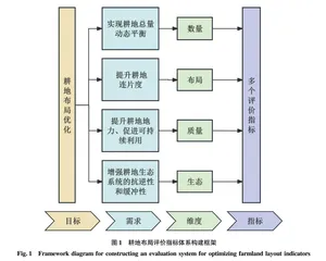
1 基于“目标-需求-维度-指标”耕地布局评价指标体系理论框架
坚持耕地数量、质量、生态“三位一体”保护理念,综合考虑广东省强调耕地集中保护的理念以及划定耕地集中整治区的耕地布局优化策略,从保障耕地总量动态平衡实现、耕地连片度提升、耕地地力及可持续利用促进、耕地生态系统抗逆性和缓冲性提升等需求出发,构建“目标-需求-维度-指标”4个维度的评价指标体系理论框架,并以广东省河源市为例,验证耕地布局评价方法具有可行性。在指标选取过程中以主导性、保护性、区域性、社会认可性、经济性、可操作性为原则[19-20],将频度分析法和专家咨询法相结合,具体步骤见图1。
2 研究区概况和数据来源
2.1 研究概况
河源市位于广东省东北部,东靠梅州市,南接惠州市,西连韶关市,北邻江西省赣州市,地处连接粤港澳大湾区与长江经济带的“黄金通道”,是粤东北山区与珠江三角洲平原地区的结合部,地势由东北向西南倾斜,地貌类型主要为山地、丘陵。河源市辖区内有西北部九连山脉、斜贯中部的罗浮山脉及东南边缘的莲花山脉,东江、新丰江等水系纵贯全域。以建设成为融入粤港澳大湾区的生态优先、绿色发展排头兵为目标,坚持以“融湾”为纲、“融深”为牵引,全力打造生态经济发展新标杆,为广东省在全面建设社会主义现代化国家新征程中走在全国前列、创造新的辉煌作出河源贡献。
由于河源市耕地保有量及永久基本农田保护任务基数大,部分耕地分布不连片,给耕地管护工作带来一定的压力。目前,河源市东源县顺天镇正在建设省级耕地集中整治示范区,旨在通过补充耕地、高标准农田建设等手段,将小块分散的非耕农用地与周边现有耕地整合成大片、连片的高效耕地,实现“零田变整田,小田变大田”,并通过陡坡与平原农用地布局优化,有效破解陡坡与平原农用地布局破碎、功能错位等问题,为广东省开展耕地布局优化工作提供一定经验借鉴。
2.2 数据来源
该研究数据包括土地数据、自然数据、社会数据以及评价数据。评价数据来源于相关领域专家评价,数据来源见表1。